Fichier:Colonisation 1914.png

Fichier d’origine (1 425 × 625 pixels, taille du fichier : 51 kio, type MIME : image/png)
| Ce fichier et sa description proviennent de Wikimedia Commons. | Accéder au fichier sur Commons |
Erreur : l’attribut name des indicateurs d’état de la page ne doit pas être vide.

Description
| Description |
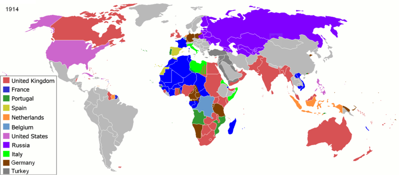
Map of major world powers by year, derived from public domain animated map on wikipedia.
As the orriginal licence of the animation was Public Domain, this image which has been derived from it is too:
|
||||||||||||||||||
| Date | |||||||||||||||||||
| Source | public domain animated map by ArdadN here | ||||||||||||||||||
| Auteur | ArdadN | ||||||||||||||||||
.jpg)
._LOC_2001620596.jpg)
Conditions d’utilisation

|
Cette image (de type historical map) devrait être recréée dans un format vectoriel, en tant que fichier SVG. Cela offrirait plusieurs avantages : voir Commons:Media for cleanup pour plus d'informations. Si une version SVG de cette image est déjà disponible, merci de bien vouloir l'envoyer. Après cela, remplacez ce modèle par {{vector version available|nouveau nom d'image.svg}}.
|
Historique du fichier
Cliquer sur une date et heure pour voir le fichier tel qu'il était à ce moment-là.
| Date et heure | Vignette | Dimensions | Utilisateur | Commentaire | |
|---|---|---|---|---|---|
| actuel | 8 novembre 2021 à 09:07 | | 1 425 × 625 (51 kio) | Randomastwritter | jubaland |
| 15 mai 2020 à 16:32 |  | 1 425 × 625 (51 kio) | Chipmunkdavis | Freeing Belgium and Luxembourg from the Netherlands | |
| 3 août 2014 à 03:05 |  | 1 425 × 625 (51 kio) | Alvin Lee | Chinese-Russian boarder | |
| 9 septembre 2011 à 00:59 |  | 1 425 × 625 (50 kio) | SpencerCS | Substantial corrections to Ottoman Empire, Africa, and the Pacific | |
| 22 mars 2007 à 10:41 |  | 1 425 × 625 (66 kio) | Roke~commonswiki | {{Information |Description=Map of major world powers by year, derived from public domain animated map on wikipedia. {{Maps of world history}} As the orriginal licence of the animation was Public Domain, this image which has been derived from it is too: { |
Utilisation du fichier
La page suivante utilise ce fichier :
Usage global du fichier
Les autres wikis suivants utilisent ce fichier :
- Utilisation sur ba.wikipedia.org
- Utilisation sur bs.wikipedia.org
- Utilisation sur ca.wikibooks.org
- Utilisation sur cs.wikipedia.org
- Utilisation sur de.wikipedia.org
- Utilisation sur en.wikipedia.org
- Utilisation sur en.wikibooks.org
- Utilisation sur es.wikipedia.org
- Utilisation sur fa.wikipedia.org
- Utilisation sur fr.wikipedia.org
- Utilisation sur hu.wikipedia.org
- Utilisation sur hy.wikipedia.org
- Utilisation sur it.wikipedia.org
- Utilisation sur ko.wikipedia.org
- Utilisation sur nn.wikipedia.org
- Utilisation sur no.wikipedia.org
- Utilisation sur oc.wikipedia.org
- Utilisation sur ro.wikipedia.org
- Utilisation sur ru.wikipedia.org
- Utilisation sur sk.wikipedia.org
- Utilisation sur uk.wikipedia.org
- Utilisation sur zh.wikipedia.org