Fichier:Earth-cutaway-schematic-numbered.svg

Taille de cet aperçu PNG pour ce fichier SVG : 612 × 599 pixels. Autres résolutions : 245 × 240 pixels | 490 × 480 pixels | 785 × 768 pixels | 1 046 × 1 024 pixels | 2 092 × 2 048 pixels | 950 × 930 pixels.
Fichier d’origine (Fichier SVG, nominalement de 950 × 930 pixels, taille : 93 kio)
| Ce fichier et sa description proviennent de Wikimedia Commons. | Accéder au fichier sur Commons |
Erreur : l’attribut name des indicateurs d’état de la page ne doit pas être vide.
| Description |
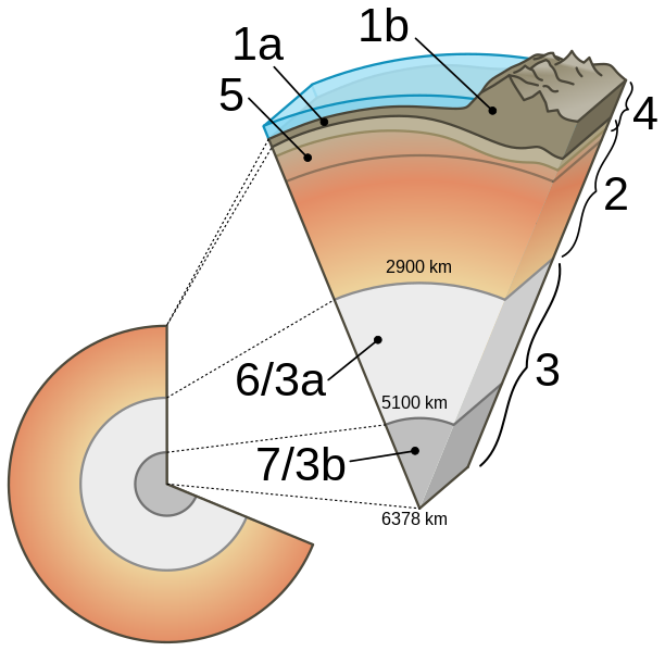
English: Language neutral version of File:Earth-cutaway-schematic-english.svg
Cutaway diagram of Earth's internal structure (to scale) with inset showing detailed breakdown of structure (not to scale). Label: 1: Crust (oceanic /1a/ and continental /1b/ crust 0 to 80 km); 2: Mantle (upper mantle, including asthenosphere, and lower mantle); 3: Core; 3a: Outer core (liquid); 3b: Inner core (solid); 4: Lithosphere (Crust and uppermost solid mantle); 5: Asthenosphere |
| Date | (UTC) |
| Source |
|
| Auteur |
Original : USGS Vecteur : |
| Autres versions |
[]
PNG:
|
| SVG information | Le code de ce fichier SVG n'est pas valide en raison d'une erreur. Ce diagramme SVG utilise du texte encapsulé qui peut être traduit facilement à l'aide d'un éditeur de texte. |


.svg)
-fr.svg)


Moi, en tant que détenteur des droits d’auteur sur cette œuvre, je la publie sous la licence suivante :
| Moi, propriétaire des droits d’auteur sur cette œuvre, la place dans le domaine public. Ceci s'applique dans le monde entier. Dans certains pays, ceci peut ne pas être possible ; dans ce cas : J’accorde à toute personne le droit d’utiliser cette œuvre dans n’importe quel but, sans aucune condition, sauf celles requises par la loi. |
Historique du fichier
Cliquer sur une date et heure pour voir le fichier tel qu'il était à ce moment-là.
| Date et heure | Vignette | Dimensions | Utilisateur | Commentaire | |
|---|---|---|---|---|---|
| actuel | 20 août 2020 à 22:32 | | 950 × 930 (93 kio) | Nefronus | putting back the twofold labeling, separating astenosphere (by the way, asthenosphere was number 5, 2 was the mantle including the lithospheric part – as in the original, no problem in that) |
| 12 novembre 2019 à 15:41 |  | 1 280 × 900 (51 kio) | Gretarsson | Reverted to version as of 00:41, 29 April 2013 (UTC): wrong labelling: 2 was _not_ the Asthenospere in its entirety but the whole sublithospheric mantle! An when overwriting an existing file, make sure that there is no adjustment of the captions in the Wikipedias or elswhere necessary (i.e. the labelling should be identical in old and new versions) | |
| 2 août 2019 à 12:00 |  | 950 × 930 (73 kio) | Nefronus | right crop | |
| 2 août 2019 à 11:30 |  | 1 023 × 930 (73 kio) | Nefronus | less aggresive colors so people don't think the mantle is magma | |
| 1 août 2019 à 12:11 |  | 950 × 930 (77 kio) | Nefronus | polished drawing; 1a and 1b for oceanic/continental crust; 6/7 abandoned (unnecessary duplicate) | |
| 29 avril 2013 à 00:41 |  | 1 280 × 900 (51 kio) | Anasofiapaixao | {{Information |Description={{en|1=Language neutral version of Earth-cutaway-schematic-english.svg Cutaway diagram of Earth's internal structure (to scale) with inset showing detailed breakdown of structure ... |
Utilisation du fichier
Les 2 pages suivantes utilisent ce fichier :
Usage global du fichier
Les autres wikis suivants utilisent ce fichier :
- Utilisation sur ar.wikipedia.org
- Utilisation sur ca.wikipedia.org
- Utilisation sur cy.wikipedia.org
- Utilisation sur de.wikipedia.org
- Utilisation sur en.wikipedia.org
- Utilisation sur en.wikibooks.org
- Utilisation sur eo.wikipedia.org
- Utilisation sur eu.wikipedia.org
- Utilisation sur fr.wikibooks.org
- Utilisation sur gl.wikipedia.org
- Utilisation sur he.wikipedia.org
- Utilisation sur hy.wikipedia.org
- Utilisation sur id.wikipedia.org
- Utilisation sur it.wikipedia.org
- Utilisation sur it.wikibooks.org
- Utilisation sur ja.wikipedia.org
- Utilisation sur ja.wikibooks.org
- Utilisation sur ko.wikipedia.org
- Utilisation sur ky.wikipedia.org
- Utilisation sur la.wikipedia.org
- Utilisation sur nl.wikipedia.org
Voir davantage sur l’utilisation globale de ce fichier.